
Walking notes - Grand Pomerolle
This is one of the more difficult walks, self guided walkers enjoy it and very occasionally guided groups do it if they are all active enough! It’s a 12km circuit which is not particularly long, but the height gain of 650m is more than average. If you would like a gpx file for this walk please contact us.
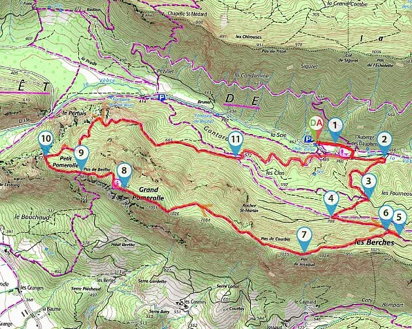
Grand Pomerolle
Distance: 12 km
Height change: 650 m
Level: difficult
Time: 6 hrs
Map: 3138 OT
Starting point: Car park at L’Auberge des Dauphins, it’s best walked clockwise.
Comments: Martagon lilies along the path in late June. Excellent views from the ridge. Saou village nearby is very pleasant and has a bar and shop.
Follow the road to the Auberge des Dauphins and park in the last car park at the end of the road. To get to the start of the walk either walk along the gated road lined by cypress trees to the Maison des Gardes and turn right across the bridge, or walk around the right hand side of the flat grassy area and continue until you reach a yellow sign – Le Pont en Beton 480m, Grand Pomerolle 6km. Continue past “Halte Equestre”, 491m, and at the clearing turn right (another yellow sign) and right again soon after, along the wide path. You reach another yellow sign, Piste des Coupes 640m, Grand Pomerolle 4.8km, and follow the path across the track. At the next crossroads, follow the path on the other side, and another yellow sign, Les Fourneaux, 698m, Grand Pomerolle, 4.4 km. Continue until you reach another yellow sign, Les Berches, 850m, Grand Pomerolle, 3.5 km, turn right. Very soon, there is a left turn up a slope, and a yellow sign saying Grand Pomerolle, 13km circuit, 4.5hrs. Follow this path to reach the ridge. Continue along the ridge passing Grand Pomerolle, Petit Pomerolle, Le Pertuis, and ultimately, L’Auberge des Dauphins, which is the large house near the car park.
Or follow the numbered itinerary:
( D / A ) Take the closed road which serves the Trianon and the Auberge des Dauphins.
( 1 ) Continue opposite then veer to the right by the vehicle width track. Cross the Vèbre on the concrete bridge (sign) then immediately turn left onto the wide marked path PR ® (yellow). Pass the equestrian stopover and arrive at a meadow.
( 2 ) Turn right and start a good climb. At the fork, continue on the main path and ignore the departure to the right. Reach a fork (les Coupes) with a forest track.
( 3 ) Cross and continue uphill, dipping slightly to the right. Join the vehicle track.
( 4 ) Cross and follow the forest path, turning left on the way up.
Reach the Berches crossroads.
( 5 ) Take the forest path on the right (Pomerolle sign), continue around 150 m and find the start of a trail on the left.
( 6 ) Follow this one. After a sustained climb, the path slants to the right and continues in almost flat undergrowth. Reach the ridge at Pas de Jossaud.
( 7 ) After enjoying the viewpoint, continue in the woods, pass the Pas de Courbis (viewpoint) and reach the top of the Grand Pomerolle, well marked by a large cairn.
( 8 ) Then continue towards the Petit Pomerolle, beware the descent is steep and can be slippery in wet weather. Find a fork at the bottom of the descent at Pas de Berlhe.
( 9 ) Begin a short climb to reach the Petit Pomerolle then go down a new junction (Petit Pomerolle marker post).
( 10 ) Turn left for a short return trip to the Pointe du Petit Pomerolle viewpoint ( beware of the cliffs! ).
( 10 ) Back, continue to the left. The trail winds downhill and turns into a forest path. This one continues following the contour line and rejoins the vehicle track.
( 11 ) Follow this track ignoring the departures to the right and to the left which follow quickly. Stay on this one to return to the departure crossroads.
( 1 ) Take the outward journey on the left to return to the car park ( D / A )
